


3Dsurvey Pilot
3Dsurvey Pilotの説明
3Dsurvey Pilot transforms your regular consumer drone into accurate surveying and mapping tool. A free addition to 3Dsurvey photogrammetry software, 3Dsurvey Pilot is the perfect tool to plan your missions and automatically capture images along with GPS data.
Post-flight processing of captured images is done easily with 3Dsurvey photogrammetry software, generating highly accurate, metric and geo-referenced results, such as dense point cloud, 3D mesh, topography map, elevation model, DSM, orthophoto. Perfect for any surveying professional.
Currently, the app supports the following drones:
• DJI
- Phantom 4 Pro V2
- Phantom 4 Pro
- Phantom 4
- Phantom 3 Professional
- Phantom 3 Advanced
- Mavic Air
- Mavic Pro
- Mavic 2 Pro
- Inspire 1 (Pro)
- Inspire 2
- Spark
Features and benefits:
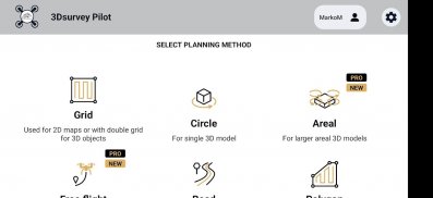
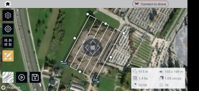
- Plan your mission - flight plans for different needs
---GRID
Single Grid or Double Grid for mapping of rectangle areas - the fastest way for planning routes with simple settings
---POLYGON
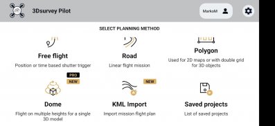
Mapping of advanced/irregular shaped areas - additional area shapes and advanced settings
---ROAD
Developed specifically for simple and effective road, rail & corridor mapping
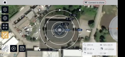
---CIRCLE
Circular mission for object mapping - always facing your point of interest for object 3D model reconstruction
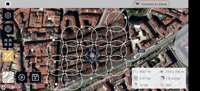
---URBANSCAN
Best mission for 3D model of large urban area
---FREE FLIGHT
Position or time based shutter trigger. Works also with Mavic mini 2 and Air 2s
---DOME
Flight on multiple heights for single 3D object
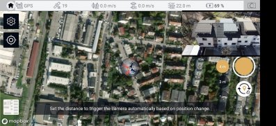
- Automated drone flight & image acquisition
- Telemetry and live camera feed during the mission
- Simple workflow with 3Dsurvey's processing software
- Flight parameters for each mission - front & side image overlap, camera angle, flying height (AGL), flight speed - can be adjusted based on the requirements of the area and the project
- Advanced settings and options for demanding missions.
Post-flight processing & analysis using 3Dsurvey desktop software:
- Capture and recreate natural environment in digital form and survey from the office. Achieve high-resolution outputs with cm-grade accuracy.
- Use of Ground Control Points (GCPs) for improving the relative and absolute accuracy of the model
- Generate and modify:
--- Point clouds
--- Orthophotos
--- Digital 3D models (DSM, DTM, DEM)
--- CAD
--- Contour lines
--- Profiles and Cross sections
--- And more
- Measure:
--- Distances
--- Surfaces, Areas
--- Volumes
- Supports any drone & any camera/sensor. Works for aerial & terrestrial data acquisition methods. rTK- and EXIF GPS-ready for instant telemetry data import.
- 3Dsurvey is developed based on 300+ land surveying projects. Tailored to serve specific surveyors' needs. Cut fieldwork time by up to 100 times.
- Hybrid engine that utilizes both CPU and GPU for up to 15x faster image processing time. Large dataset support - 1000+ hi-res images.
- Compatible with third-party sources, data from LiDAR, Sonar, SLAM, terrestrial scanners. Seamless workflow for further combination with photogrammetric point clouds.
Usage information
Make sure you have the latest firmware installed and the app is up to date. The app follows the flight plan and does not avoid obstacles automatically.
3Dsurvey accepts no liability for damage, injuries or legalities from the misuse of this app. Use only in safe environments and follow your local drone regulation.
3Dsurvey Pilot - バージョン 1.8.15
(29-09-2022)3Dsurvey Pilot- APK情報
APKバージョン: 1.8.15パッケージ: si.modriplanet.pilot3Dsurvey Pilotの最新バージョン
他のバージョン


同じカテゴリのアプリ


その他のおすすめ...


